Current Nature: Rain, Rain, Come To Stay - How We Measure Precipitation On Nantucket
Sarah T. Bois, PhD •
Of all the places I’ve lived, Nantucket is one of the most attuned to daily weather and climatic patterns. It likely has something to do with the maritime past, but, even today the island’s food, mail, and ability to come and go as we please is dictated by weather - it’s full community awareness.
One important aspect of our weather is precipitation. To help us understand precipitation patterns on Nantucket and how they fit into regional and national pictures, the Linda Loring Nature Foundation (LLNF) has served as a precipitation center for the island since 2014. We monitor precipitation with multiple, complementary projects. Since 2014, we’ve been taking daily precipitation measurements as part of the Collaborative Rain, Hail, and Snow Network (CoCoRaHS), a national community science network started by the Colorado Climate Center at Colorado State University in 1998. The strength of this data set lies with the thousands of monitors collecting data with the same exact equipment (rain gauge) while using the same set of standard protocols in all 50 states (plus Canada and the Bahamas). The data collected are then publicly available for anyone to use. Users include the National Weather Service, emergency managers, insurance adjusters, and the USDA, among others.
You can view the daily precipitation data here: https://www.cocorahs.org/Maps/.
Nantucketers seem to have rain on the brain lately – well, lack of rain anyway. After four months of drought conditions, on November 7th, the state’s Executive Office of Energy and Environmental Affairs re-evaluated the Mass drought status. As the report noted, “In the Islands Region, Nantucket has improved, while Martha’s Vinyard has worsened, both now at a Level 2 – Significant Drought.” That seems like good news after more than a month of Level 3 (Critical Drought), but is still significant and accompanied by water-use restrictions.
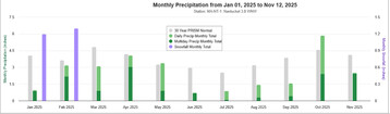
Our precipitation data at LLNF can show us just how devastating the drought has been. Precipitation, including snow, was roughly normal through the end of May in comparison to the 30-year norm. June precipitation at LLNF was only 23% of the normal amounts and July through September were less than 35% of normal each month. October rebounded with 1.3 inches over the historic norm, but a decent amount of rain in one month doesn’t immediately counteract months of well below average precipitation. Keep in mind, we’re only partially through November, so we could have more rain (or snow) yet!
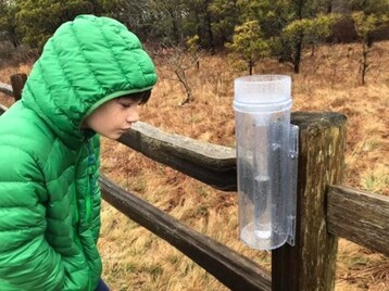
Many of us have had the experience of talking to someone in Madaket where it’s raining and being in town where the streets are still dry. More rain gauges across the island mean that we can get a more accurate picture of local precipitation patterns. To aid in the effort, you can join the CoCoRaHS program by installing a rain gauge where you live or work. In 2015, LLNF helped establish a CoCoRaHS station at the Nantucket New School where the students have incorporated their daily measurements into lessons on climate, weather, and science. The more rain stations, the better! There is a reliable volunteer in Tom Nevers and we are always open to more! Contact Dr. Sarah Bois (stbois@llnf.org) for info on how to set up a rain gauge near you.
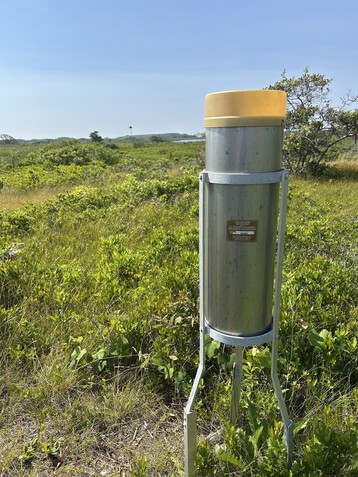
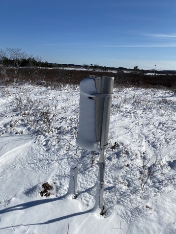
While CoCoRaHS is available for anyone to participate, LLNF was selected as an official climate site to collect daily precipitation data for the National Oceanic and Atmospheric Administration (NOAA) in 2015 as part of their Cooperative Weather Observer (COOP) program. The COOP program is the nation's largest and oldest weather network established in 1891 to formalize the collection of meteorological observations and record climate conditions in the United States based on the ideas of Thomas Jefferson. And we still use a lot of the same methods today! The network’s observers have generated consistent long-term climate data. Climatic atlases for the country are based on decades of observations from COOP observers. These data play a critical role in efforts to recognize and evaluate the extent of human impacts on climate across local to global scales. For the past 10 years, the LLNF COOP site has been adding to this historic data set and has helped create more accurate weather predictions for the island.
To complement both of the precipitation data collections, LLNF now has a full weather station that records temperature, wind speed and direction, relative humidity, and more. The best part is that you can access that data from the comfort of your own home at any time: https://www.licor.cloud/dashboards/a25c5b2d-421d-41db-9ed1-14a9b1ac76f6/true/. You can see what the weather on the western end of the island is doing at that moment or check out the past week, month, or however long. The data are useful to us and our research at the LLNF property, but we also hope it’s useful to the community as a whole.
The Linda Loring Nature Foundation continues to collect valuable precipitation data both to contribute to national data sets, but also to provide educational opportunities for the Nantucket community. We’re also happy to help others who’d like to establish a CoCoRaHS rain gauge for themselves.